Bexhill to Hastings Link Road
East Sussex
The need for economic regeneration in the Bexhill and Hastings area had been a focus point for planning policy and development plan strategies for over 40 years in response to economic and demo-graphic imbalances. Plans and policies had therefore been developed through time to address the need for regeneration and the associated problems of poor access both within the area itself and external to it.
The Access to Hastings Multi-Modal Study was commissioned in 1999 to consider how transport would best contribute to regenerating the area's economy while minimising the impact on nationally important protected areas such as 'Sites of Special Scientific Interest' and 'Areas of Outstanding Beauty'.
In 2001, the Secretary of State for Transport stated that: 'A regeneration strategy for Hastings needs to be developed which shows clearly how transport and other measures may be implemented to ensure a sustainable economic future for the area'.
In response to this, the Hastings and Bexhill Task Force was established and developed a plan for the area built around 5 themes - urban renaissance, excellence in education, support for business, broadband connectivity and transport improvements.
The transport theme identified a range of improvement measures including the concept of a local link road to overcome the poor connections between Hastings and Bexhill.
The East Sussex County Council prepared a range of route options and in February 2004 the County Council consulted with the statutory bodies and the public to determine the level of support for the scheme and public views on the most appropriate route.The new link road will be 5.6km long and will start at the A259 in Bexhill. It will run along the line of the disused Bexhill to Crowhurst railway line and then pass around the northern side of the Combe Haven Site of Special Scientific Interest (SSSI). Crossing Crowhurst Road and the Hastings to London railway line, it goes round the southern edge of the Marline Valley Woods SSSI before joining Queensway just north of Crowhurst Road.
Oxford Archaeology was commissioned by the Hochtief Taylor Woodrow Joint Venture to undertake the archaeological works which were required as part of the contract. In addition to Iron Age and Roman remains materials were also found dating back to Saxon to Medieval times.
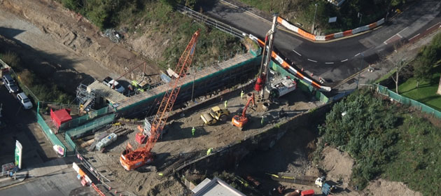
Piling commenced in April 2014 and was required to support seven new bridge structures along the line of the new 5.6km link road. The diameter of the piles varied from 600mm to 1200mm and with depths up to 24.0 metres. Due to the varying ground conditions present along the route the piles were installed using both CFA and Bored & Cased Rotary techniques. The piles were drilled through very soft alluvium and founded into dense sands and predominantly siltstones of the Ashdown Beds.
Case Studies
- Avonmouth Resource Recovery Centre
- Capital Square, Edinburgh
- Heads of the Valleys Dualling
- Wedge House, Blackfriars Road, London
- Dundee Railway Station, Dundee
- Kemsley EfW Plant, Sittingbourne
- A6 Broughton Bypass, Preston
- A6MARR Bridge B010, Stockport
- Building S2, Kings Cross, London
- A6MARR Bridges B014 & B015 Manchester
- 2 Arena Central, Birmingham
- A6MARR Bridge B002, Stockport
- Dundee V&A Museum, Scotland
- Medway Valley Crossing, Kent
- Moelfre Lifeboat Station, Anglesey
- Bognor Regis NRR, Phase 2, West Sussex
- Tidal Basin Road, London
- Bexhill to Hastings Link Road
- A465 Heads of the Valleys
- Building P1 - Kings Cross Central, London
- Belvers Bridge, Southampton
- Cray Bridge, Scotland
- Sainsburys, Northampton
- Limmo Shaft, Crossrail, London
- Carlsberg Brewery, Northampton
- River Forth New Crossing, Scotland
Case Study Facts
- Client: East Sussex County Council
- Consulting Engineers: Jacobs
- Main Contractor: Hochtief/Taylor Woodrow Joint Venture Carillion Construction Ltd
- Role: P J Edwards & Co (UK) Ltd acted as Piling Contractor
- Specification: Specification for Highway Works
- Equipment: Mait 260 Piling Rig - Rotary Cased Piles
Llamada P140-TT Piling Rig - CFA Piles
Llamada P150-TT Piling Rig - CFA Piles - Contract Period: April 2014 - March 2015
- Contract Award Value: £737,000

